


2018 School Spending Survey Report
Mainland Libraries Aid Maria Victims with Money, Mapathons
Update: ALA president-elect Loida García-Febo told LJ that disaster relief organizations and library groups like REFORMA (the National Association to Promote Library and Information Services to Latinos and the Spanish Speaking) are still assessing the damage. ALA has established contact with the University of Puerto Rico Library and the Puerto Rican chapter of REFORMA—the organization’s largest—she reported, and is just beginning to gauge their needs.
Update: ALA president-elect Loida García-Febo told LJ that disaster relief organizations and library groups like REFORMA (the National Association to Promote Library and Information Services to Latinos and the Spanish Speaking) are still assessing the damage. ALA has established contact with the University of Puerto Rico Library and the Puerto Rican chapter of REFORMA—the organization’s largest—she reported, and is just beginning to gauge their needs.
“Please continue supporting Puerto Rican colleagues and libraries,” said García-Febo. “As our colleagues in the Island start rebuilding libraries, we want to support their efforts. At the same time, libraries here in the USA, can assist library users with loved ones in Puerto Rico by exploring ways to support Puerto Rican patrons by holding community forums and brainstorming ways to address their needs; working to connect patrons with friends and family across the Caribbean and in Mexico; and providing counseling services and access to disaster relief agencies and resources."
“Please continue supporting Puerto Rican colleagues and libraries,” said García-Febo. “As our colleagues in the Island start rebuilding libraries, we want to support their efforts. At the same time, libraries here in the USA, can assist library users with loved ones in Puerto Rico by exploring ways to support Puerto Rican patrons by holding community forums and brainstorming ways to address their needs; working to connect patrons with friends and family across the Caribbean and in Mexico; and providing counseling services and access to disaster relief agencies and resources."
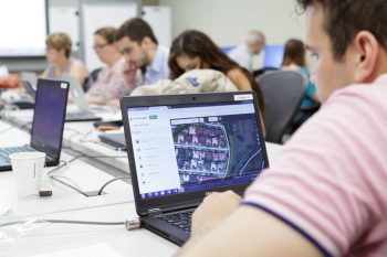
Participants in the University of Miami Library mapathon
Photo credit: Brittney Bomnin
Hurricane Maria caused catastrophic damage from September 18–20 in Dominica, Guadeloupe, the U.S. Virgin Islands, Puerto Rico, the Dominican Republic, Turks and Caicos Islands, and southeastern Bahamas.
At press time, most of Puerto Rico’s 66 public libraries and numerous academic libraries had not been able even to issue updates on their damage. Maria completely destroyed the island’s power grid, which had already suffered extensive damage from Hurricane Irma, leaving practically all 3.4 million residents without electricity or communications. About a quarter of the island should have power in November, Puerto Rico Gov. Ricardo Rosselló said at an October 2 news conference, but full restoration may take up to another six months. More than half of the island’s residents were still without running water at press time.
REACHING OUT
The American Library Association (ALA) is accepting donations to support library relief efforts in the Caribbean Islands, Puerto Rico, and Mexico—where a severe earthquake caused extensive damage in the states of Puebla and Morelos and the greater Mexico City area. Said ALA President Jim Neal, “We encourage our members to consider donating to the ALA Disaster Relief Fund to help support recovery and rebuilding of libraries affected by both natural disasters as well as Hurricanes Harvey and Irma.” Florida International University (FIU) has partnered with ALA to gather status reports and updates on libraries in the Caribbean to help determine how best to use money raised.
To support relief efforts, library software provider SirsiDynix is donating all proceeds from its Power of Libraries store to help libraries in affected areas. Use the code “RELIEF” at checkout and all proceeds from any store purchase will go directly to the ALA’s Disaster Relief Fund.
The Society of American Archivists (SAA) has posted a number of links for disaster funding for archives and other cultural resources that have been impacted, including the SAA National Disaster Recovery Fund for Archives.
CRISIS MAPPING FOR RELIEF
While national relief efforts have been doing what they can to work within a severely damaged infrastructure, and organizations around the world are collecting donations to support affected areas, academic libraries have found a way to help from the mainland.
When the Red Cross requested geospatial data to help with relief operations in Puerto Rico, Mexico, and beyond, the Humanitarian OpenStreetMap Team (HOT) stepped in to provide mapping services. And during late September and early October, librarians in institutions from Los Angeles to Boston organized to host mapathons—inviting students, faculty, and staff from their campuses as well as members of the surrounding community to contribute to an ongoing crowdsourced mapping project.
OpenStreetMap (OSM) is an open source, collaborative mapping project inspired by Wikipedia. Created by British entrepreneur Steve Coast in 2004, it uses data collected from field maps, GPS coordinates, and aerial photographs by more than two million registered users. Contributors enter data into the OSM database on the project’s website and work with it using a variety of map editing software. Local knowledge is important to the project—users log information not only on streets and buildings, but also schools, bus stops stations, landmarks, trails, waterways, and more.
During national disasters or times of crisis, aid organizations have had to rely on whatever mapping data is available—which often, especially in vulnerable or isolated areas, proves to be inaccurate or incomplete. The nonprofit HOT formed in response to the 2010 Haiti earthquake. “We came together as a loose network of volunteers looking at how we could use OSM and other open data platforms to respond to disaster and to promote positive change in the world," HOT executive director Tyler Radford told LJ.
HOT now has operations and volunteers all over the world, with donor-funded programs and projects in five countries. It mobilizes a community of “crisis mappers”—volunteers who help compile maps on OSM for non-governmental organizations (NGOs), aid responders, residents of crisis areas, and others affected by disasters, often by crowdsourcing efforts—and serves as an interface between the OSM community and humanitarian organizations: distributing data, deploying aid to the field, and developing open knowledge and tools for on-the-ground data collection. Some 45,000 people have contributed their efforts over the past seven years.
The areas that require mapping are those most impacted by disasters and, later, where rebuilding work is taking place. A list on the organization’s website allows anyone to contribute or organize mapping events.
SIMPLE TOOLS TO HELP

Participants in the University of Miami Library mapathon
Photo credit: Brittney Bomnin
The process is simple, using either the area tool—which allows a user to draw a polygon around a building shown on a map, mapping it to the structure’s corners—or the line tool, which allows a user to draw roads. The OSM task manager, found on its website, also makes the division of labor easy, breaking mapping tasks down into squares on an overlaid grid. Once the user selects a square, the task manager locks it so that no one else can work on it at the same time. The user zooms in, traces buildings and roads or marks areas such as farmland that have neither, and then either marks the task as done or saves work to return to later. The finished map work is then uploaded to OSM, and the square changes from white to orange on the map.
For the second step of the process, another user proofs the work, making sure the shapes match what is shown on the original map. Anyone can validate work, although team organizers often request that a user first get some experience with the mapping tools. Any errors are sent back for correction. Once the square has been validated, it shows up as green on the map and is considered done. A progress bar on the side of the screen gives the task’s percentage of completion and validation. Finished data is sent to the relief organizations that have requested it, in printed form or formatted for phones or GPS devices.
While the process itself is simple, noted Radford, it can be difficult for volunteers to see photographs of the devastation. "You see people’s homes, pretty close up, that are really destroyed, and it can be tough. But it's also a way for people to connect with what's happening on the ground without actually being there. I think it provides meaning for a lot of our volunteers."
Relief organizations are encouraged to send feedback from the field back to HOT, which is shared with the volunteers who worked on the affected areas. "Maps are interesting in themselves, but they're meaningless unless someone is actually using them to make decisions on the ground that could potentially save people’s lives in an emergency situation,” Radford said. “We do our best to surface those kinds of stories from the ground as much as possible back to our volunteers."
MAINLAND MAPATHONS

In September HOT posted a call to action on its blog for help mapping areas affected by hurricanes Irma and Maria, the Mexico earthquake, and South Asia flooding.
Alex Gil, digital scholarship coordinator at Columbia University, and his colleague history professor Manan Ahmed, saw the notice and decided to organize a mapathon at Columbia’s Butler Library for Friday, September 29. His Facebook post announcing the event drew the attention of librarians at other universities, who expressed interest in hosting mapathons of their own. Within days Gil had galvanized librarians and faculty from Boston University; Rutgers University, NJ; Trinity College, Hartford, CT; the University of Miami; and the University of Nebraska–Omaha, among others. Participants planned and publicized their events through an informal email chain and the hashtag #prmapathon over the following week, and that Friday a chain of mapathons took place in university libraries across the country.
Organizing the mapathon at Miami University (UM) needed to be simple, digital humanities librarian Paige Morgan told LJ, because the campus and community were still recovering from Hurricane Irma. She got immediate buy-in from her supervisor and dean when she proposed the idea, and the library’s communication team helped get the word out.
Responses were immediate and enthusiastic; Morgan secured a second room. She gathered a couple of library colleagues and graduate students to learn the OSM tools ahead of time so they could provide support during the event, and three days later the UM Disaster Relief Mapathon drew between 60–70 people—students, faculty, staff, contingents from FIU and Miami Dade College, and a scattering of people with no university affiliations who had friends or family in Puerto Rico or Mexico, or who simply wanted to help. The youngest was about seven years old, said Morgan; the oldest in their early 70s. The majority of the participants, Morgan noted, were women.
Morgan led off with a brief intro and tutorial on the OSM platform. "I kept the presentation short and sweet, emphasizing that geographical data comes from all sorts of sources for both public and commercial purposes,” Morgan told LJ. “That can mean that the data available for any particular location is uneven and tends to reflect the socioeconomic status of the location in question—which means there's much more finely grained data for major cities like Miami…than there is for cities in…Puerto Rico and Mexico.”
The volunteers all picked up the OSM tools quickly, and set to work. Although OSM can accept more granular information—marking buildings as residential or commercial, for instance—Martin asked people not to go into detail beyond mapping the contours of buildings and roads. “All we had were the satellite photographs with a bird’s eye view, and that just isn't enough information,” she noted. “It's really important to create a good dataset that people on the ground can build on, rather than create a dataset that's uneven because some people make good guesses and some people have made guesses that were well intentioned but wrong.”
Some volunteers worked for an hour or two, while others lasted for the entire three-hour event and only left because the library was closing—“I was sorry to send them away," said Morgan. Fortunately, once participants have created an OSM account they can continue their work from home, or anywhere with a computer and Internet connection.
The platform’s ease of use, said Morgan is a credit to the OSM team. “They truly want to be a community-focused organization that is open to local participants from all over, and the way to do that is to create an interface that is oriented toward people who have knowledge of their community but not necessarily sophisticated GIS knowledge."
Morgan considers the UM mapathon a success. People were excited to contribute to relief efforts, and—particularly for the non-librarians in the group—interested to hear more about the origins and uses of mapping data. "In addition to being thrilled that we could find ways to do something that should tangibly help…I was really excited to show people how uneven data can be,” she said. “It's so easy to take data for granted, because we use it all the time—in Google maps, in Twitter, in Facebook, in so many parts of our lives, and it's easy to forget that not everyone has that sort of data. Also that part of taking data for granted means assuming that the data is actually correct, or that it's created through neat and well thought out procedures. In fact, data is created through terribly messy procedures that often can be really harmful for underrepresented communities.”
Morgan has received queries from UM’s medical and marine campuses asking about future mapathons, and she is looking into setting up more events. "Now that we have the format pretty much down, it will be easy to take those to other campuses, or to hold more versions of this event on the main UM campus," she told LJ. “I'm really excited about having run this event.... I think that it has already started conversations on our campus about where data comes from…. I hope will lead to other conversations about the ethics of data creation and the ethics of data use."
Several libraries in other institutions have expressed interest in organizing their own mapathons. Radford hopes that public libraries will be interested in hosting mapping groups as well, as they have the space and networking capabilities to bring people together. There is still work to be done on data for Puerto Rico and Mexico, Radford told LJ, and when that is finished “there are always the disasters that don't make headline news that we're working on year round—there are always things for people to contribute to." HOT provides services for not only natural disasters, but projects such as mapping refugee camps in Northern Uganda. "There are all different ways people can contribute depending on what their interests are,” Radford added, such as improving public health or education—nearly any humanitarian cause can use good mapping data.
Interested libraries can look at the projects on HOT’s website or email queries to info@hotosm.org. UM doctoral student Alok Amatya has also created a quick guide for working with HOT’s disaster relief efforts.
"After you've spent 30 minutes mapping with us, a week later we can come back and show you a photo of your very map being used by a relief organization on the ground in Puerto Rico,” said Radford. “So it's a really tangible way to help. Your hand has actually been involved."

Added To Cart
RELATED


RECOMMENDED


TECHNOLOGY

ALREADY A SUBSCRIBER? LOG IN
We are currently offering this content for free. Sign up now to activate your personal profile, where you can save articles for future viewing
ALREADY A SUBSCRIBER? LOG IN
Thank you for visiting.
We’ve noticed you are using a private browser. To continue, please log in or create an account.
Add Comment :-
Comment Policy:
Comment should not be empty !!!