


2018 School Spending Survey Report
USGS topoView | eReview
The United States Geological Survey’s topoView offers access to maps in a way that's educational and entertaining.
U.S. Geological Survey (USGS) topoView
CONTENT The United States Geological Survey (USGS) began to map the United States’ topography in 1879. Many early map libraries were lending libraries rather than archives, and innumerable maps were borrowed and never returned. As a result, there is no single complete set of USGS historical maps. USGS topoView offers free access to the remaining 180,000 scanned and georeferenced maps. The topoView interface was created by the National Geologic Map Database project in support of the topographic mapping program managed by the USGS National Geospatial Program.
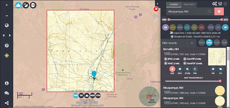
USABILITY By selecting “Get Maps” from the homepage, USGS maps can be searched by map name or location. Topographic maps published by USGS are named for the largest or most centrally located community or by the most prominent physical or natural feature. Searchable locations can be as general as counties and as specific as individual physical addresses. Once an area is accessed via the topoView search tool, users can select the desired map from a list sorted by name, date, scale, or state (for natural features that overlap multiple states). When a map is selected, a records table appears along the right side of the interface, providing information such as quadrangle name, map year, edition, scale, and a list of downloadable files in various file formats. The map information window also includes map name and date, primary state, map scale, and imprint year. Further, an information icon in the information window provides metadata collected from the map collar, such as edit and filed check years, Geographic Names Information System (GNIS) cell ID, survey year, woodland tint, and projection. Coordinates of all maps are available as Degrees Minutes Seconds (DMS), Decimal Degrees (DD), Universal Transverse Mercator (UTM), and Military Grid Reference System (MGRS).
The database’s succinct interface belies the depth of information offered. While many of the features of the interface are intuitive enough to lead to serendipitous discoveries, perusing the Help Guide (from an icon in the static left column) or a quick viewing of the introductory YouTube video uncovers the layers of rich visual and factual information available in each iteration of these historical USGS maps. An enhancement to the visual information is USGS topoView’s innovative and deceptively simple feature: the map transparency slider. The slider allows users to overlay historic maps and a current—or “base”—map with varying degrees of transparency to create meaningful comparisons of map details over time.
PRICING USGS topoView is free to the public, courtesy of the United States Geological Survey.
VERDICT USGS topoView is simultaneously educational, informative, and entertaining. This combination is as ideal for the casually curious library patron as it is for researchers of U.S. rural and urban development and infrastructure. In addition, the ability to download maps makes this a resource that reaches beyond its inventive online interface.

Added To Cart
RELATED


RECOMMENDED


TECHNOLOGY

ALREADY A SUBSCRIBER? LOG IN
We are currently offering this content for free. Sign up now to activate your personal profile, where you can save articles for future viewing
ALREADY A SUBSCRIBER? LOG IN
Thank you for visiting.
We’ve noticed you are using a private browser. To continue, please log in or create an account.

Add Comment :-
Comment Policy:
Comment should not be empty !!!